L u M o n t e

3D Planwerk

Let's work together!
We are ready to assist you with all your projects. Contact us today and let's find the best solution for your needs together.

shape-img
hero-img

LuMonte
3D Planwerk

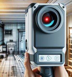
Your Partner for Precise 3D Measurements and LIDAR Services

img

180 +

Happy Customers

shape-img

25+

Years
Experience
about-img
LuMonte 3D Planwerk

Damage mapping and inventory documentation

Document the current state of your house in detail with LIDAR technology. Greatly facilitates damage mapping for historical buildings and subsequent restoration planning.

shape-img
Innovation

Modernize Your Home:
Precisely and cost-effectively with
LIDAR technology

Measurement and Design:

Use precise LIDAR scans for optimal planning and design of your property. Perfect foundation for gardens, terraces, and outdoor areas.

Renovation and Remodeling:

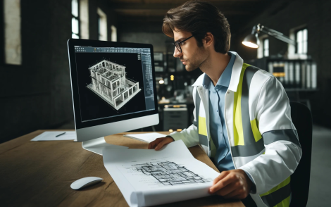
Create accurate 3D models of your house for precise planning of renovations and remodels. Optimize collaboration with architects and contractors.

Damage and Insurance:

Document the current state of your house in detail with LIDAR technology. Facilitates damage assessment and insurance claims for damages such as fire or flooding.

Our Services

Precise and Fast!
Rely on LIDAR.

01

Precise Measurements

Our 3D scans offer highly precise capture of terrain and buildings. The data is expertly converted into CAD-compatible formats, allowing you to work efficiently.

02

Documentation

We capture the current state of your objects with accuracy and detail. This provides you with a reliable foundation for your planning and analysis.

03

Digitization

Our plan conversion enables the transformation of PDF scans and paper records into CAD data. We create 2D and 3D plans according to DIN standards to ensure your projects run smoothly.

shape-img
About Us

Get to Know LuMonte 3D Planwerk:

• Part of LuMonte GmbH & Co. KG, Baden-Württemberg
• Many years of experience in the construction and real estate sector
• Wide range of expertise thanks to a large network of specialists
• Cooperation with AABSys – GIS Systems for future-oriented construction projects
• Over 500 specialists for your orders
• Results according to international and German standards
• Personal local contact person
• High cost efficiency
• Secure information according to DIN ISO/IEC 27001

600+

Projects

500+

Specialists

25+

Years Experience

8

Countries Represented

Application Examples

Versatile Applications of
LIDAR Technology

From Sketches to
Realistic 3D Models

Experience how hand-drawn
sketches are transformed into
detailed 3D models to plan your projects precisely.

Damage Assessment
and Insurance

Use LIDAR technology for precise
capture of damages for quick
and accurate damage assessment.

Precise Planning of
Your Renovation Work

Create accurate 3D models
of your house for error-free
and efficient implementation
of remodels.

Accurate Measurements
for Perfect Planning

Use precise LIDAR scans
for optimal design of
your garden and property.

Customer Reviews

What Our Customers Say:
Quality that Impresses

Anna M.

Architect

Delivered quickly and everything was millimeter accurate.

Thomas K.

Civil Engineer

We are very satisfied with the result.

Julia S.

Real Estate Developer

Everything fine, gladly again.

FAQ

Your Questions about LIDAR Technology

Do you have questions about LIDAR technology and how it can help you with renovations, remodels, or garden design? In our FAQs, we answer the most common questions and show you how this modern technology can revolutionize your home.

LIDAR (Light Detection and Ranging) is a technology that uses light in the form of a pulsed laser to measure distances. By scanning surfaces and capturing the reflected light signals, LIDAR can create precise 3D models of objects and environments. This technology is used for detailed measurements, mapping, and planning.
The duration of a LIDAR scan depends on the size and complexity of the building. Typically, a single-family house can be scanned within a few hours. Processing and converting the scanned data into CAD formats can take a few days, depending on the scope of the project. However, we always strive to deliver the results as quickly as possible.
Yes, your data is safe. At LuMonte 3D Planwerk, we place great emphasis on protecting your information. All data is stored and managed according to the highest security standards and DIN ISO/IEC 27001. You can be assured that your data is in safe hands with us.
To conduct a LIDAR scan of your house, simply contact us via our contact form or give us a call. We will schedule an appointment for the scan and discuss all the details with you. Our team will come to your home, perform the scan, and process the data into CAD formats that you can use for your projects.
img

Let's Work Together!

We are ready to assist you with all your projects. Contact us today and let's find the best solutions for your needs together! Use our simple and straightforward contact form for a non-binding inquiry. We look forward to hearing from you!